Banks Peninsula
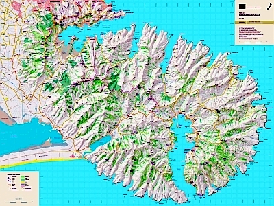
This is the only topographic map to show the whole of the peninsula on one sheet at this scale, giving emphasis to the walking tracks in this popular Christchurch recreation area. It is very easy to read with a clear road network and full topography.
| Scale | 1:60 000 |
|---|---|
| Edition | 2 |
| Year | 2010 |
| Price | $20.00 |
Technical Details
Large format 840x630mm.
20m contours. 1km grid. 10 minute geographic graticule.
New Zealand Transverse Mercator projection
Printed on high wet strength paper.